Sunday, 28 April 2024

2024 Walking South Pembrokeshire - Day 4

Sunday 28th April 

Bosherston to Castlemartin via St Govan's & Stack Rocks

Today there were 6 fortifications to "Bag" as well as some rather spectacular natural features.


From Bosherston village I headed for St Govan's Chapel, the legendary home of a monk, St Govan, who supposedly hid from pirates in a cleft in the rock - the impression of his ribcage can still be seen!! 

As there are possibly 52 steps down I chose to give it a miss today.


Moving swiftly on!! I set out across the clifftops along the ancient wave-cut platform that is now used primarily as a Military Firing Range.

Yesterday the forecast had been for light breeze from the east and lots of sunshine. Definitely no rain, not even mizzle till around 2pm! 

Huh! They lied!! I started off in a blustery westerly, straight in the face and an overcast, threatening sky. However, the scenery made up for it. 


At Bosherston Mere, a little way to the west of the chapel are two spectacular chasms. I took a photo of the 1st but not the 2nd, so called "Huntsman's Leap," where legend had it that a huntsman chasing a fox jumped the gap. This so frightened him when he realised what he'd done that he fell off his horse & died!! 


With all this spectacular beauty to my left the view of Military Target Vehicles to my right seemed a little incongruous. 

The area was first used by the military in 1939 and was purchased in 1948. It is still used today with live firing on week days when the range is closed. 

Just as well my walk here was at the weekend!!


My first prehistoric fort was hardly visible. 

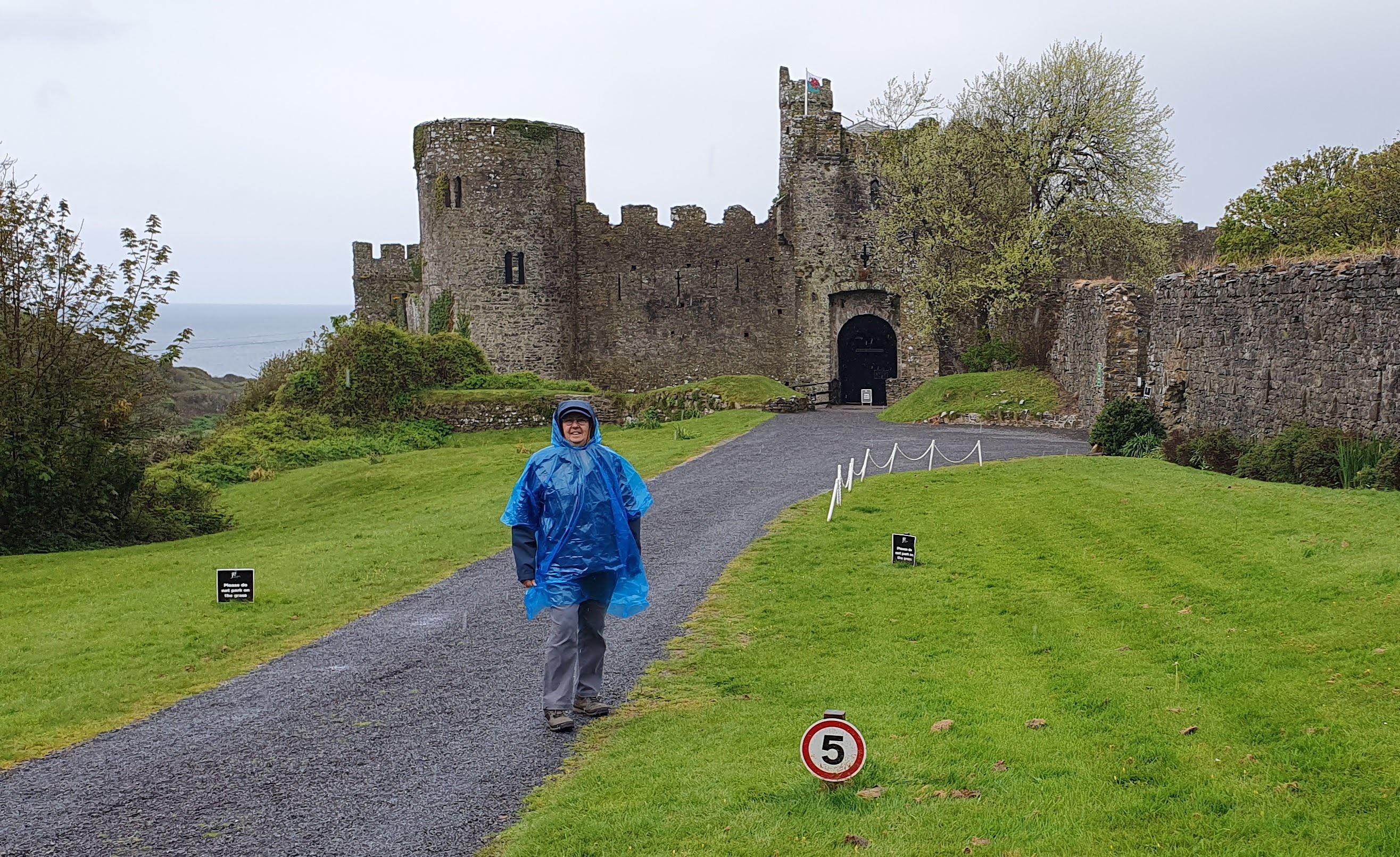
The next, Buckspool Down or Castle Fort was slightly more visible as a series of raised ridges near a range lookout station. It was about here that it started to rain and I had to don my skimpy blue poncho.


Evidence of earlier military activity was all around. Shell or shrapnel 'scrapes' in the turf where something had hit and gouged a furrow. The range wardens must spend a lot of their time collecting the debris as it is a much used and loved recreational area. 

There were also the remains of structures that I remembered from my youth as far less overgrown. 


Onward past Bullslaughter Bay to the remains of a fort that allegedly is there but I believe is so overgrown that I couldn't see it. 

The Crocksydam Promontory fort that I saw was nothing like the one on the information post. 

Maybe because I wasn't brave enough to get close enough to the edge to take the necessary photo!!

I carried on walking and was now able to take off my fetching but noisy poncho. The sun even threatened to shine!


The next fort was at Flimston Bay. 
Both this and Crocksydam forts were probably erected sometime between 600 BC and 43 AD. Flimston fort is defended by a series of three earthen banks and ditches on the landward side, enclosing a fairly large area. On the eastern side of the fort interior are a number of shallow hollows that may represent platforms for supporting huts.


Stack Rocks and the Green Bridge of Wales were the next features to snap. 

The Rocks were crammed with Razorbills and Guillemots (known locally as Elegugs). Even with the wind blowing the sound away from me they certainly made a bit of a racket. 

Not only were they on the rocks there were also flocks of them floating about on the water.

I carried on past Stack Rocks and on to view the Green Bridge of Wales. Probably, as it is such a photogenic structure, the authorities decided to build a fenced wooden platform from where one could take the perfect picture without plummeting over the cliff edge! I duly obliged!


I then headed north, away from the firing range and up towards the west/east ridge that extends from Freshwater West to Freshwater East. Once part of the way up I had to take a long detour to bag my penultimate fort, Merion Camp. In my mind Merion Camp is the military  firing range and Training Barracks on the range. I never knew of the existence of another, earlier structure up on the ridge behind the barracks. There it was, behind a huge bank and hedge, I could see nothing!


So much for my two mile detour. 

I had to carry on eastwards until I could take the road back westwards towards my final destination, Castlemartin. 

To make matters worse, it started to rain again, only a bit of a shower but annoying none the less. 

Imagine my surprise (& delight) when I realised I could see the missing fort much better from this side!

That put a spring in my step to cover the last few of miles to Castlemartin. Unfortunately there was another disappointment as the castle "mound," that appears quite extensive on the map, is a bit of a flat field hidden away behind private houses and high hedges.


I contented myself with a photo of the Cattle Pound that is now used as a roundabout.

The "castle" is behind the hedge on the left.

I also visited the plot of land which had been owned by my  grandfather's family several generations ago!

Another walk completed and another 11.5 miles covered. Halfway through the walk and I've covered around 49 miles. Anyone would think it was planned!!

If you would like to sponsor me just click on the link below which will take you to my fundraising page at Give as you Live Donate:

https://donate.giveasyoulive.com/fundraising/margs-pembrokeshire-100-mile-2024

I also believe that the Milford Mercury has covered my story. The link is below:

https://www.milfordmercury.co.uk/news/24278737.pembroke-dock-veteran-72-sets-off-100-mile-solo-walk/


Saturday, 27 April 2024

2024 Walking South Pembrokeshire - Day 3

Saturday 27th April

Manorbier to Bosherston via Freshwater East and Stackpole Quay

Only once before on my 10 previous walks have I had to contend with such rain!! We woke up today to fairly heavy rain and a bit of a blow from the east. Still, I couldn't let a drop of rain stop play!! 

We arrived at Manorbier castle where it was still raining so waterproof jacket plus a very lightweight, fetching, blue 'poncho' was dress-order for this walk. The castle was the birthplace of Giraldus Cambrensis (Gerald of Wales; 1146–1223), one of Wales's greatest scholars and patriots. Initially it was a motte-and-bailey castle which had a wooden keep defended by a palisade and earthworks embankments. In the early part of the 12th century, William de Barri used locally quarried Limestone to strengthen the fortification. 

 I think the Number 5 sign refers to the Mental Age of anyone mad enough to walk on a morning like this!!


The rain stayed with me down to near the beach and back up beside what I used to know (in my childhood - many moons ago) as the Dak Café. I think its a private house now. This was where a decision had to be made. Take the Coastal Path or the road? I decided that, given the weather, the rough terrain, my less than youthful legs plus my newly discovered "Old Codgers!" sense of unbalance, I had better stick to the road. 


It was, for the most part a fairly quiet, narrow tarmac 'track' rather than road. The route followed the kind of Pembrokeshire lane that terrifies most tourists given its narrow, high-banked, twisting nature. 


As I climbed back up, heading for Freshwater East, I could admire the view and the ever lightening sky. 

Maybe the rain would ease? 

I could but hope.


The going was good if a little wet and muddy and I was soon at the start of 
Freshwater East. 

Down the hill to the Park where our chalet is situated and then back up the lane to Trewent and onwards to Stackpole Quay. 

I had thought to bag another Iron Age Fortified Promontory Fort between Trewent Point and Stackpole Quay. 

Even though I wasn't on the Coastal Path I thought I could get to it down a farm track; the farmer had other ideas. 


A barbed-wire wrapped gate with a heavy locked chain proved my undoing!! 


Soon I was heading down to Stackpole Quay which is probably one of my favourite swimming spots locally. There is a small quay in a little cove carved out by limestone quarrying in the past. When the tide is in it proves the ideal swimming pool; calm, sunny (when it's shining!) and usually child/dog free. 

The 'masses' head for Barafundle Bay in the summer which, when I was young, would be blissfully people-free even in the height of the season! People generally didn't walk back then (in the Dark Ages!!)
I met up with Denise in the NT café and we had an excellent cup of coffee each & I had the obligatory Bacon Roll!!


From there it was across the fields to Bosherston Lily Ponds on the NT property that was Stackpole Court. I wanted to visit because it tied in with the first day of my Scotland walk in 2022 when I roamed around Cawdor Estate woodland. 

The Cawdor's owned and lived at Stackpole Court after marrying a 'local' girl. They were mainly responsible for extending the Lily Ponds, a playground for the rich & landed gentry. 


The Court was requisitioned during the War and, according to local legend, was so badly trashed that the Cawdor's decided to demolish rather than refurbish the main house. 


I think it more likely that it was demolished to avoid Death Duties on a property that was surplus to requirements as the family had moved back up to Scotland. 


The land and remaining 'service' buildings were sold/gifted to the National Trust who keep it as an area to be enjoyed by everyone. 


The area around the Lily Ponds was another of my favourite haunts growing up. 


Little did I know, as a young teenager charging around the ponds and playing on the cliffs overlooking the ponds, that I was playing on Fishpond Camp, a promontory fort dating from the prehistoric era!!


After negotiating the last of the little footbridges across an arm of these extensive lakes I was able to make my way up to the car park where Denise was waiting. 

Another day done. 
Another 10+ miles completed.

Also, if you would like to donate to my two charities, The WRAC Association (which is free to join for all Female Military veterans and serving personnel) and the VC Gallery (Pembroke Dock) combating loneliness & social isolation for veterans and the community please follow the link:

Friday, 26 April 2024

2024 Walking South Pembrokeshire - Day 2

 Friday 26th April 2024

Tenby to Manorbier (& Beyond!!)

Tenby War Memorial


The day started with Denise trying to get herself run over taking a photo of me at the gates of Tenby War Memorial. 

The gates are on a very busy corner with a narrow pavement in front. The only place for the budding photographer to stand is right in the middle of the road. 

My wife is my hero - the things she does for me!! 

My reason for starting there is that the gate arch has two plaques, one either side at knee height. As you look at the gates the one on the left is to the ATS and the one on the right to the WRAC. 

A very misty Tenby in the background

You can probably guess from my clothes that the weather was not so good today. Mostly mizzle, some slightly heavier rain and the very occasional dry-ish spells. Needless to say, every time I decided it had stopped it started to rain even heavier!!


After Tenby my next point of interest was Penally Camp and Range (the coastal path has to take a detour away from the range Danger Area) 

Once I'd turned towards the sea opposite the camp I noticed an information panel explaining that the area had been used during WW1 to train soldiers for Trench Warfare.

I had another interview today with Richard Hatch of BFBS Radio. That's the second one! They go out at around 1.30pm on BFBS Afternoon. Even though I'd mentioned yesterday that Membership of the Association is now free for all female military, both veterans and serving, that had been edited out. 

More steps down &
hazardous limestone
path up again!

My next fortification was after I had climbed up the track from Lydstep Bay and then climbed back down . . . and then up again!! 

Oh Goody I heard myself mutter . . . . More steps!

Actually climbing down wasn't too bad even if it was a bit hard on the knees.

The problem I had already had and was about to have was clambering up (or down) a very worn, lumpy, wet pathway on limestone. Trip hazard nightmare. Poles were no use - it was back to baby-crawling up and bum-sliding down!!


After my scary ascent and once I'd rounded the corner and crested the headland I could see Skomar Defended Enclosure on the next headland an Iron Age structure. 

It certainly was well defended from the sea although I suspect much of the original enclosure on that side had crashed into the sea over the years. 


From the land side the mounds and ditches that would have protected its inhabitants were still visible although much diminished over time. 

I tried to take photos but my photography isn't good enough to show what my eye could see.

All I managed to convey was a rather pleasant green field with a few slopes. 

Never mind - at least I was aware of what had been there. Definitely something that I would have quite happily walked past previously without realizing what that little word "fort" on the map really meant.

Onwards I went towards my next 'goal' which, unfortunately, is on MOD land and not accessible during the week due to Live Firing! 


Old Castle Head Promontory Fort is on the headland to the south of Manorbier Camp. As its name suggests it was another fortified enclosure constructed on a headland. The cliffs around this part of Pembrokeshire are about 200 feet high so the sea was Iron Age inhabitants best defence. 


From here it was a brisk walk to Manorbier castle only stopping to say hello to the two MOD Guard Service personnel 'manning & womanning' the gates to Manorbier Camp.

We had a good chat & I forced my calling cards on them. 

I was so busy chatting to Kirsty & ?Steve? that, I'm sorry . . . . I think I've mis-remembered your name!! 

Put it down to senility!!


Manorbier was a welcome stop. I went into the castle but didn't need to pay the entrance fee as I only wanted a cup of coffee from the café. Well, I thought that was all I wanted until I saw the cheese scone. I explained to the lovely lady behind the counter that I was intending to stop my walk at the castle today and gave her my calling card. She very kindly only charged me for the Yummy Cheese Scone and also generously gave me £5 towards my walk. 


Another day under my belt. Another 14.7 miles under my belt (well, feet!!)

Tomorrow is Manorbier to Bosherston. Only 2 Iron Age fortifications to see or not see on the way. 

I'm going to be able to visit possibly my favourite part of South Pembrokeshire, Stackpole Quay. I do hope the café is open!!

If you  would like to sponsor me please follow the link to my Give as you Live page: https://donate.giveasyoulive.com/fundraising/margs-pembrokeshire-100-mile-2024


Thursday, 25 April 2024

2024 Walking South Pembrokeshire - Day 1

Thursday 25th April

Llanteg (near Amroth) to Tenby

We thought we were up early enough (I hadn't slept much - too much going through my mind!) but but tomorrow I think we'll set off a bit earlier to miss the "rush-hour" traffic around Tenby!
We arrived at Llanteg and Denise dropped me off at the end of the lane by Trelessy Farm. I walked up the hill in search of my first "Fortification", a fortified enclosure overlooking the sea. I managed to get a good photo of the view from the field before and then carried on down the lane to the next gate!

Uh-oh!! A field full of very young, very inquisitive, cattle - my worst nightmare. 

I could just about see a ridged mound that might have been the enclosure (arrow marks the spot). I certainly wasn't going to get any closer!!

Once in Amroth I walked westward on the promenade with the sea to my left. There was a useful lo stop and then I had to do a little climb. I'd already dropped down over 400ft and now I had to climb back up again but only 250ft - up an almost vertical path. Well, that tested the lungs. 

Once up I knew two things:
 
1st - although the light breeze was cool I had too many layers on for such climbing

2nd - I was going to be going up & down like a fiddlers elbow today.

The views were good though.

The going was fairly good and, before I even realised it, Wiseman's Bridge and Saundersfoot hove into view. People and dogs were enjoying the sunshine. It all looked idyllic. 

And then I had a Zoom Interview with Richard Hatch of BFBS Afternoon Radio. I think I plugged the WRAC Association being available for free for anyone who had served, even 1 day, in the WRAC. Of course the interview had to take place at a tricky part of the walk when I had to hold my phone and open gates and avoid buses and cars.

Fortunately the interview finished before I had to attempt another massive, lung-busting climb as the original lower level path had been obliterated by a landslide. That was lung-buster/knee cruncher number 2 and I was still standing. 

Once I'd clambered down to Coppet Hall I could then walk the short tunnel that connects to Saundersfoot. Tunnels would make coastal paths much easier on the knees & hips!!

I took a break by the harbour but forgot to take a picture as I had to swap the battery on my Gizmo. The local seagull thought I was opening something edible I discouraged him from getting too close.

I phoned Denise, very pleased with myself at the pace I was walking. "I'll soon be with you in Tenby" I foolishly said. Little did I know.

Although, as a family, we have walked much of the Pembrokeshire Coastal Path. I realised that we had never tackled Saundersfoot to Tenby. So it was definitely on my "Bucket List". I now know why we'd never walked it - It's a bloomin' nightmare.

Down & Up over a hundred feet each time. Doesn't look much i the photos - but it is!!


Fabulous views, walking on the edge of the world sometimes, the path had crashed to the sea in some places and it had been re-routed. 

My legs turned to jelly not just from fear of heights but sheer exhaustion from clambering uphill and thumping downhill. it was lovely seeing all the wild flowers and the amazing views but, by around 2 miles from Tenby I decided that continuing along the Coastal Path would do too much damage so I took the decision to head up the lane towards the A478 and then took the Cycle Route 4 into Tenby. 

Denise met me at the edge of town and walked with me to Castle Hill where she took a photo of me by the remains of the medieval castle. 


I reciprocated with a selfie of the pair of us with St Katherine's Island Fort in the background.

The Fort was built between 1867 & 1870 in case invaders should attempt to land and march on the dockyards at the Milford Haven Estuary. It wasn’t fully armed until 1886. 

We then headed back up form the Quayside to where she had parked the car and she drove me back to our chalet accommodation.

So, first day over and everything aches!!

But, at least my feet are ok . . . . it's just the rest of me falling apart!!

I'm hoping that tomorrow will be a little easier on my hips and knees.

Looking at the map I seem to have done a fair bit of Ascending and Descending.

Also, according to the App I only stopped moving for 3 minutes!! Well that's a great big whopper!!

Looking at my Steps App I did 20,886 Steps!! Yes my hips would definitely agree with that - 10,000 upwards and 10,000 downwards!! 

If you would like to sponsor me please follow the link to my Give as you Live donation page:


Wednesday, 24 April 2024

2024 Walking South Pembrokeshire - Day Before Start

Wednesday 24th April 

Today we motored down to our chalet accommodation, Stella Marina, Trewent Park, Freshwater East via two very important stops.

Firstly at Cardiff West Services to meet Debbie Amphlett of South Wales Branch WRAC Association. I had to hand-over two raffle prizes. One had been won by Kath Smith of the same branch and the other was for Debbie to work her pyrography magic to make it presentable as a raffle prize at the Area AGM.

Can't eat till I've finished my blog!!

That done we headed for north Pembrokeshire, to Solva to pick up a delicious Seafood Platter from Mrs Wil the Fish. Yummy - a great start to my walk. 


Having driven to Solva we then had to head back south to Pembroke Dock for a grocery shop and on to Freshwater East to our accommodation. Denise took a lovely picture of Newgale beach and St Bride's Bay - taken from a moving car!!


I have been quite busy on the PR front (thanks to WRACA & Curios PR). I am apparently going to do some "live" interviews on BFBS Afternoon Radio with Richard Hatch. Tomorrow, (Thursday 25th) will be the first of possibly several interviews. Richard's programme goes out between 1300 - 1600hrs on Weekdays.


Richard Hatch, BFBS Afternoon 1300-1600hrs

For those wishing to meet up with me during my walk I have the following suggestions:

Monday 29th Apr @ 1100hrs - VC Gallery PD NAAFI Break

Wednesday 1st May @1000hrs - VC Gallery PD (calling briefly as I pass)

Thursday 2nd May @ 3/4pm - Lawrenny Quayside Tearooms (where I finish my walk)

If you would like to sponsor me please follow the link:

https://donate.giveasyoulive.com/fundraising/margs-pembrokeshire-100-mile-2024


Tuesday, 23 April 2024

2024 Walking South Pembrokeshire - Heading to the Start

Tuesday 23rd April

Tomorrow we head down the M50 & M4 to South Pembrokeshire to start my 11th Solo 100 Mile Charity Walk.

All my kit is packed ready to put into the car. It comprises a large and a small suitcase packed with multiple changes of clothes, a couple of pairs of boots, several changes of wet weather gear and loads of pairs of socks. I'm also taking a couple of back packs and all my navigation "gizmo's" and other electrical gear. I'm hoping that being well prepared for rain might keep it away. The weather forecast is not looking good but it is what it is. I've been very fortunate on all my previous walks so can't really complain.


Today was supposed to be a day of comparative ease but, like all plans, didn't quite work the way we'd planned. We found that the beans we'd started a few weeks ago needed to go into the ground. That meant the veg patch needed weeding and we needed to construct a couple of wigwams for the plants to grow up. Then we had to plant the beans and wrap some netting around temporarily to keep the rabbits off! There was still time to enjoy the peace and quiet of the garden and the beauty of the wild spring flowers.


Back home it was time for a hot bath, hot meal and then Dr Denise had her annual job of taping up my feet ready for the 100 Miles. 


Tomorrow we drive down to our rented chalet via Mrs Will the Fish in Solva.


She prepares the best seafood platters ever. Possibly not the best nutritional start to my walk but certainly the tastiest.


You can support me and my two charities by clicking on the link below which will take you to my fundraising page at Give as you Live Donate: