Sunday 23 April 2023

2023 Walking Ireland - Day 6


Sunday 23rd April

Bundoran Circular 3.33mls & Murvagh Beach and Golf Course 6.17mls

Today was supposed to be a walk from Killeter village in South Tyrone to Pettigo on the Tyrone/Donegal Border. After my walk on Friday I did a recce to see where my start point was going to be. I found the start, realised there was a VERY large hill to climb up a mile or so  and then down again the other side before more or less joining the road that I then took to drive to Pettigo and then onwards to Donegal!! I thought of my poor feet and decided that 9 or so miles of pounding on a metalled road surface was not going to fill me full of joy!! A re-think was in order.

Today is Sunday (and also St George’s Day – Hope all my English relations/friends/readers had a good day!)


Sunday is a day of rest & time to spend with the family so I kind of did!! We drove to Bundoran (in two cars) and had very nice breakfast at the Salty Fox. Then we parked the cars at the other side of the town near the sea-front with the intention of walking round the headland, back past the Salty Fox and back through the town to the car. Best laid plans!! There was “an incident” on the headland with lots of police so we had to make a detour and miss the headland out. 


George & Julia decided to go back to their car & return home whilst Denise bravely (foolishly?) decided to stay with me to walk past the Salty fox to the headland and bay the other side. I had to keep pushing it!! The clouds were ominous but I just wanted one more photo. Just a bit further, the clouds will blow away!! We got drenched!! 


The rain started at the furthest point away from the car . . . . of course!! 

By the time we got to the car the rain had stopped but we were soaked. 

Denise, however, is still talking to me!!

We dried off back at our home-from-home and had a snack and a hot drink. 


Then George kindly drove me all the way to Murvagh Beach which is right next to his Golf Club! He always tells me how fortunate with the weather he is on his links course. the course is situated on a peninsula jutting northwards out towards Donegal Bay. 

It’s where the channel from the bay narrows at the peninsula point before heading up to Donegal town itself.

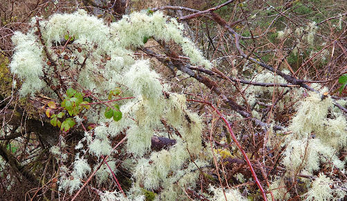
It was a short walk over the dune to the beach and there before me was a long stretch of sandy beach heading northwards with the mountains of County Donegal as a backdrop.


I headed towards the point on the damp, firm sand. 

There was a bit of a blow (as you would expect beside the sea) but it was wonderful to be beside the sea again.  

There was intermittent sunshine although the clouds were a little threatening. 


I walked far enough around the point to be able to see, far in the distance, the “estate” where Julia & George live. I waved but I don’t think Denise & Julia saw me!! By this time the clouds looked VERY threatening; that dark, purple-black. plumped-up kind of cloud that looks over-filled with rain. I turned back the way I’d come and headed back down the beach hoping I could out-walk the rain that I was sure was coming. There were a few spits & spots but I had my umbrella handy . . . . but it wasn’t needed! 


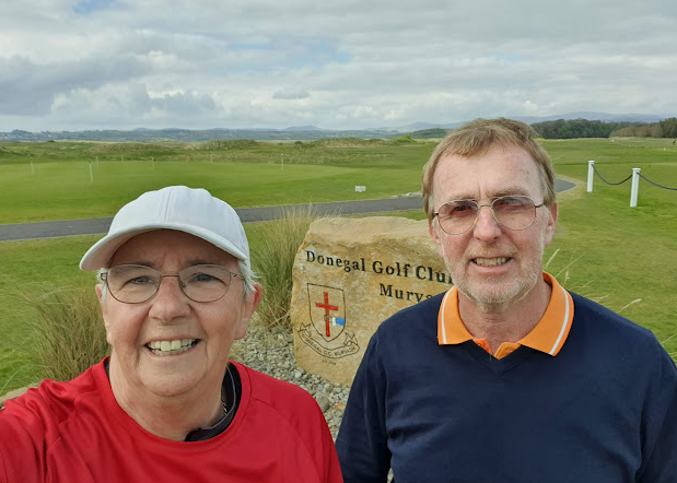
I made it back off the beach and then had another mile or so of wooded avenue to walk before arriving at Donegal Golf Club, Murvagh where I was to meet George. As I walked up to the clubhouse he was there to greet me. 

Photos were taken and we got back in the car and he drove me home for a superb Sunday Dinner (which is why this Blog is late!!)

That means that I have completed another 9.5 miles towards my total. Just two more days to go . . . . in County Fermanagh so wish me luck with the weather!!

Saturday 22 April 2023

2023 Walking Ireland - Day 5

Saturday 22nd April 


Lough Navar Loop – 8.7 miles

“It'll be fine tomorrow Marg. Sure we're in for a bit of rain about 1’ish but it won't be much.”

George's words rang in my ears as I drove past Belleek towards Garrison and the rain started! It got heavier and heavier as I neared my starting point. If ever you visit Ireland a visit to the Navar Forest Scenic Drive is a must. I used it in order to access my start point near Meenameen Lough. This time I was going clockwise round the route. I was well wrapped against the rain & carried my umbrella. 

Plus Point Number 1 – far less wind today.


I tried a few times to take some photos but couldn’t get the hang of juggling umbrella & phone at the start!! The first couple of miles was the same old forest trails but with added water in the form of puddles & rivulets where wheel tracks had cut grooves. 

I decided to give Lough Anlaban a miss and headed for Lough Achork instead (it appeared to have a better pathway round it.) I’d hardly seen a soul or a car up till then. Blow me down but there was a car parked (not mine!!) right by the opening onto the pathway!!


It was a delightful little lake with a comfortable, well maintained pathway all the way round. (The “car-driver” was at the far end looking just as damp as me!!) I thought what a magical place it would have been for young (accompanied) kids.

Ever the primary school teacher I thought of all the magical stories to be made up from the tiny rock cars, magical woodland, tree & rock formations! 


Plus Point Number 2 – magical places.


After the Lough it was back onto the metalled trackway which I now had to share with the (supposed) one way traffic. Needless to say you always get at least one awkward customer going the wrong way & hell for leather coz they’re going uphill. 

Compared to my other forest walks this was positively overcrowded!! Although my route only followed the road for about a third of the way it was fairly busy; there again, it is a Saturday. 

Plus Point 3 – coz it’s raining there are fewer people at this popular tourist spot!


There was water everywhere: 

the calm loughs, 

the streams & rivers rushing down beside me, 

tumbling over rocky outcrops & crashing over waterfalls.


I also realised how clean the air must be as I saw great swathes of silvery-green lichen festooning the trees beside the rushing river.

I came off the road and back onto the forest track where my route crossed the Sillees River and onto the Ulster Way.


I’ll be walking more of the Ulster Way on my last two days. George now says that Fermanagh is the wettest place on earth!! 

Now he tells me?!

Back to the tranquillity of the forest with their majestic spruce and the sombre open spaces of upland bog and the remains of felled trees. 

All I could hear, apart from the incessant chirping of small birds hidden in the dark forest, was the constant spattering of rain on my umbrella.


Even in the gloomy dampness there were sudden bursts of colour: the golden glow of gorse, the pale yellow of large clumps of primroses and an amazing cushion of burnished moss blushing at the forest edge. 

Plus Point 4 – as my Aunt used to say – we need a bit of colour!


I was by now about three-quarters of the way round my route when I spied Lough Navar. 

It was a much larger body of water than Lough Achork. 

There was no pathway round it but I was able to get pretty close to the water’s edge.


By this time I was feeling decidedly  soggy and just a tad fed-up!! Just as well it wasn’t too far to go. 


I almost gave up taking photos until I saw Plus Point 6 – at least I wasn’t walking in the kind of weather than uproots, knock’s down and snaps large spruce trees!!

Hot cuppa and feet-up albeit in the comfort of the ‘sun-room’


Friday 21 April 2023

2023 Walking Ireland - Day 4

Friday 21st April


Big Bridge Figure of Eight - 11.5 Miles


The Figure of Eight comprises two trails, the Bannadoo Trail and the Mullyfa Trail . . . . or from now on, the Red Trail & the Blue Trail. Both of them are additions to the International Appalachian Trail (IAT) which forms the southernmost part of both trails


I had done some of the Red Trail on day 1 and day 3 so there were few surprises. 

A large Limestone Lough beside a ruined hunting lodge, wide corridors between majestic spruce trees and  where the Trail moved away from the road, wide stony paths with annoyingly large lumps of not-so-crushed-stone. 


The route continued north-eastward from where I’d left it yesterday and met up, not too far away, with the Blue Trail. Reader, I confess, I chickened out!! I didn’t fancy twice up the middle section so I went halfway, turned round, came back to the junction & carried on the Blue Trail!! 


There was a modicum of reasoning behind it; the wind was a north-easterly, blowing in my face now but at my back for the last bit! 

Also I didn’t fancy the uphill climb for the 2nd time at the finish!!

The Blue Trail surface was generally much kinder to my feet with a better (or older) crushed stone more like sand and chippings.


I came across fauna on the trail at last – three sheep! 


They looked at me and,as I got closer, they turned tail and ran. 


I came to an area, Mullyfamore Bog Regeneration Scheme, where they are trying to restore endangered Atlantic Bogs by careful management. 

With that in mind I was horrified to see the litter around the Information Panel. Plastic drink bottles and a can & lid of John West Salmon! Ironic!


I was now in open country and as I had thought, the hefty breeze was in my face. I caught up with my worried sheep again as I headed towards the Killiter Road. 

It was downhill for this bit but still into the wind. I had just realised, as I crossed the Glendergan River, that I had a fair stretch of uphill again. 


I glanced to my right and was shocked to see 4 dead foxes, each hanging on a fence post, presumably as a deterrent to other predators. 

I'm sure they create havoc with lambs and chickens.

Once on the Big Bridge/Killiter Road is was fairly plain sailing (well, walking!). A few lumps & bumps, a lot more traffic until I got closer to the forest and away from habitations, the wind was at my back and all was well with the world. 


Don’t you love place names? 

Some of them here on the ‘Emerald Isle’ are slightly tongue-twisting, especially as I don’t find Gaelic as phonetic as Welsh. 

And then you get some that just tickle your fancy. 

Today’s best place name was . . . SHESKINAWADDY . . . . Isn’t that amazing!


Day 4 done & dusted, a mere 11.5 miles (cos I missed a bit!). Half-way time-wise and just over halfway distance-wise!! 

A cuppa and blackcurrant jam on hot buttered toast eaten sitting in the sun finished the day off well.

If you’d like to donate to my Give as you Live page at: 

https://donate.giveasyoulive.com/fundraising/margs-ireland-100-mile-charity-walk-2023

Thursday 20 April 2023

2023 Walking Ireland - Day 3


Thursday 20th April 

Leaghany to Lough Derg Quay - 15.5 miles


The day started with my chauffeur, George, driving me on VERY minor roads to my starting point in the Forests of County Tyrone. Even George admitted that he was seeing parts of Ireland that he’d never seen before!! He dropped me off at Leaghany, just over the border into Northern Ireland. 


It was a quiet and peaceful start, just the calls of multiple little birds unseen in the thick forest either side. 

I was also aware of the swish of the spruce trees as they swayed back & forth in the breeze. 

I was also fairly sheltered from the wind and also often from the sun.

For the first part of the walk I was following the International Appalachian Trail. Geologically, back in the day, Ireland, Scotland, Wales (basically the UK & Ireland) were joined to North America. There is a famous walk in the States called the Appalachian Trail, presumably walking in the Appalachian Mountains.


The IAT route runs from west Donegal in the Republic of Ireland to Larne, Co Antrim in Northern Ireland across some unforgiving paths in places. 


I have walked some of the IAT around the Bluestack Mountains on previous visits but its not well signposted in the Republic as far as I can see.


After a while the trail continued to the North-west whilst I headed southward towards Lough Derg. I came out onto a patch where the trees had been felled leaving an amazing vista to the west of me. 

I could see the wind farm near where I’d been dropped off and the Leaghany River which formed the border between Northern Ireland and the Republic.


Throughout the Forest Areas, particularly in Northern Ireland, there are many information panels dotted around. They make fascinating and informative reading. Often they describe the multitude of fauna that thrive in the forest and wetland habitats. 

I like to think that I’m not a noisy walker. I don’t have and background music or talking when I walk (although I do “sing” in my head – silently!!) I don’t stamp around (although all my walking boots seem to have a slightly annoying squeak!!)


However, any fauna that might be within a mile of me obviously hears me and is long gone. So far I have heard LBJ’s (little brown job birds), Cuckoos every day. Seen Mallards and Canada Geese  (I recognise them), a bird of prey of some sort, crows and possibly a jay. As for deer, otters, red squirrels and any other animal, not a site or sound. However, for the second day I found the hoof-print of deer!! I only found it by accident when I thought I’d try a shortcut where I thought I could cross the Leaghany River at a ford – some chance!! Raging torrent springs to mind!! I retraced my steps back to my original route which gave me a chance to take a picture!

After an early lunch stop in the sun I continued on my trek along the very straight road the brisk breeze right in my face again! I got my first glimpse of Lough Derg and Station Ireland Retreat.


That part of the walk was very counter-intuitive: I could see (vaguely) my end of walk but I was walking away from it!! For some considerable time!

At last I headed back northwards with the wind and sun at my back. It wasn’t far to the quay on Lough Derg where pilgrims can visit ‘Saint Patrick’s Purgatory’ on Station Island.


The site's Christian origins date back to fifth or sixth century and since the 1000’s it has been a place of pilgrimage. My chauffeur, George arrived and we walked in the footsteps of Pilgrims along the Pilgrim Path which leads to Saints Island which used to be the site of and earlier monastery.

We also saw one of the largest rowing boats in Ireland, a 50’, clinker-built monster that required 12 men on 4 oars. Given that the boat is huge we were staggered that it was licensed to take 150 passengers across to the island!

Hiccup of the Day? I encountered a very large, fully loaded logging truck on a very narrow road with a tiny verge either side. He came up behind me; I was aware there was a vehicle so I glanced back and stepped to the edge of the road. I looked back properly and there, looming over me was an enormous lorry-cab. I realised I needed to move some more but the verge was narrow and sloping away from me! As I teetered precariously he edged forward (and I was able to notice what a lovely, new, shiny blue the lorry was!!) The wagon was fully loaded with massive tree trunks. I thanked my lucky stars that he was a far more thoughtful driver than the ones I encountered in Scotland last year. To be fair to them, they were on private forestry roads whilst my courteous driver today was on a public road.


Another 15.5 miles done and a well-earned cuppa and cake in the sun to celebrate.


Wednesday 19 April 2023

2023 Ireland - Day 2


Wednesday 19th April 2023

Day 2 Belleek to Pettigoe - 17 miles

The morning started well, a bit blowy but sunny. Denise & I left our home-from-home reasonably early to travel via Ballyshannon to Belleek. There was method in our madness. Belleek boast an amazing little coffee shop, The Thatch, where I aimed to grab a bacon & egg sandwich and a coffee before starting walking.


Imagine my disappointment when we got there to find it was closed!! 

We checked the opening times – 9am to 5pm – it was just after 9 but it was VERY closed!! 

Oh well – I keep complaining that I put on weight doing these walks – enforced dieting today!!


Today is a day of lakes (Loughs), hills and roads. I was going to walk in a very wet, stony, peat-bogged area of Ireland. No chance of any “off-piste” routes as I’d have been up to my neck in water & bog!! 


After yesterday I wasn’t looking forward to the constant pounding my poor feet were going to get; however, some of the roads were very small, underused tracks with grass growing down the middle or with flat, grassy verges so I got some respite.


Dotted around, few and far between, were houses and cottages, some permanent residences and some holiday homes/lets. 


Their views were amazing if you like wild and secluded.


My walk started in sunshine with a blustery breeze. It also started reasonably flat but lulled me into a false sense of security as I was faced with a hill. 


Not what I’d wanted to see a third of the way into my walk!! 


It was one of those hills that went on, . . . . . and on . . . . .oh good I’ve finished . . . . oh no it goes on . . . . and on!! 

The higher I climbed the windier it got. 

The windier it got the cooler it got (despite the climbing!) 

The cooler it got the more I regretted starting out in a thin walking-top and my Pancreatic Cancer T-Shirt) 

Back on went my fleece. 


When I reached one of the supposed summits I had a glorious view over the Lough towards the hills I had been walking yesterday (Red Arrow marks the spot).

I had a late lunch break by some empty Holiday Properties. They afforded me some shelter from the wind and a step to sit on whilst I munched on my sandwiches whilst I wrapped myself in every available bit of extra clothing I carried!!


As I continued towards Pettigoe I came across the Tully Custom & Excise Patrol Station which was built c.1930. When I looked it up they think it might have been moved from another place  along the road but it was used , probably up until 1990’s.

After many more uphill’s and downhill’s  I came to an area of peat bog which is quite extensively being “farmed” for peat logs.


Unlike the peat bricks which I have seen being dug out at some considerable depth this seems to involve “scraping” the surface with a machine that then produces the peat as what frankly I would describe as “turds”!! 

Along with the stripping of the peat surface there seems to be a load of detritus involved, mainly wooden pallets and loads of white, heavy-duty bags.

By journeys end I felt thoroughly battered by the wind. The last half of my walk was directly into the teeth of the wind and the sun had all but disappeared.


Never mind, a cuppa and another of Julia’s coffee and walnut muffins soon put the world to rights.

Another chunk off my total mileage and a visit to a spiritual setting on the cards for tomorrow.

If you would like to sponsor me you can donate to my Give as you Live page at: 

https://donate.giveasyoulive.com/fundraising/margs-ireland-100-mile-charity-walk-2023